- Home
- About
- Team
- Contact
-
Categories
- Aggregate
- Agriculture
- Aircraft
- Attachments
- Construction Equipment
- Articulated Dump Trucks
- Asphalt Pavers
- Asphalt Plant & Components
- Backhoe Loaders
- Boom Lifts
- Boring Equipment
- Compact Track Loaders
- Compactors
- Concrete Mixing
- Concrete Paving
- Concrete Plant & Components
- Concrete Pump
- Crawler Dozer
- Directional Drill
- Excavators
- Forklifts
- Front Shovels
- Generators
- Light Towers
- Mechanical Frame Trucks
- Motor Graders
- Scissor Lifts
- Scrapers
- Skid Steers
- Soil Stabilizers
- Telehandlers
- Water Wagons
- Wheel Loaders
- Wheeled Dozers
- Consumer Items
- Cleaning Machines
- Clothing
- Construction Materials
- Consumer Electronics
- Generators
- Heating & Cooling Equipment
- Household Goods
- Industrial & Construction Supplies
- Luxury Goods
- Medical Equipment
- Office Equipment
- Parts
- Portable Structures
- Product & Fuel Tanks
- Scrap Metal
- Sheds
- Shipping Containers
- Shop Equipment
- Shop Tools
- Sporting Goods
- Storage Wars
- Survey Equipment
- Traffic Control Equipment
- Warehouse Equipment
- Waste & Recycling Equipment
- Water Equipment
- Welding Equipment
- Yard & Garden
- Cranes
- Forestry Equipment
- Marine Support & Infrastructure
- Military
- Oil & Gas
- Rail
- Real Estate
- Restaurant Equipment
- Trailers
- Boosters
- Container Chassis
- Curtain Side Trailers
- Deck Over Trailers
- Dollies
- Dual Lane Trailers
- Dump Trailers
- Equipment Trailers
- Food & Concession Trailers
- Fuel & Lube Trailers
- Gooseneck Trailers
- Highboy Trailers
- Jeeps
- Lavatory & Shower Trailers
- Live Bottom Trailers
- Livestock Trailers
- Logging Trailers
- Lowboy Trailers
- Office Trailers
- Oilfield Float Trailers
- Pneumatic Bulk Trailer
- Pole Trailers
- Pressure Washer Trailers
- Reefer Trailers
- Reel Trailers
- Refuse Trailers
- Roll Off Trailers
- Sand Blasting Trailers
- Scissorneck Trailer
- SPMT's
- Spray Foam Trailer
- Steam Trailers
- Step Deck Trailers
- Tank Trailers
- Trailer Components
- Trombone Trailers
- Utility Trailers
- Vacuum Trailers
- Van Trailers
- Water Craft Trailers
- Vehicles
- Vocational Trucks
- Asphalt Trucks
- Bed Trucks
- Beverage Trucks
- Bridge Inspection Trucks
- Bucket Trucks
- Cab & Chassis
- Car Carrier Trucks
- Chip Trucks
- Concrete Mixer Truck
- Concrete Pump Trucks
- Curtain-Side Truck
- Digger Derrick
- Dump Trucks
- Emergency Vehicles
- Feed Trucks
- Flatbed Trucks
- Food & Concession Trucks
- Fuel & Lube Trucks
- Grain Trucks
- Grapple Trucks
- Hook Lift Trucks
- Hot Oil Trucks
- Hydro-Vac Trucks
- Logging Trucks
- Lugger Trucks
- Reefer Trucks
- Reel Trucks
- Refuse Trucks
- Roll-Off Trucks
- Semi Trucks
- Service Trucks
- Sewer & Cleaning Trucks
- Shunt Trucks
- Silage Trucks
- Slinger Trucks
- Snow Plow Trucks
- Steam & Wash Trucks
- Sweeper Trucks
- Tank Trucks
- Tow Trucks
- Traffic Control Trucks
- Vacuum Trucks
- Van Trucks
- Water Trucks
- Welding Trucks
- Winch Trucks
- Auctions
- Real Estate
- Locations
- FAQ
- Services
- How to Pay
- Careers
- Français

Issues with our payment partner have been resolved. We apologize for the inconvenience.
Time Left:
Bidding History
- Loading . . .
Time Left:
Location:
Highway #16, Clavet, SK
by placing a bid you agree to all
terms and conditions of mcdougallauction.com
Time Left:
Location:
Highway #16, Clavet, SK
by placing a bid you agree to all
terms and conditions of mcdougallauction.com
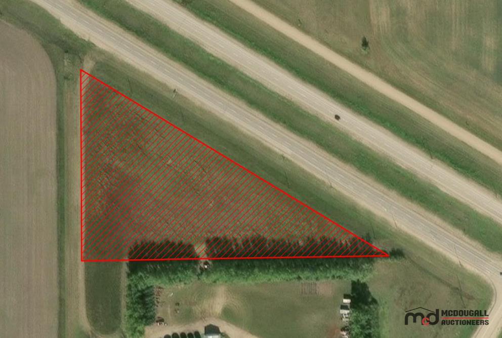
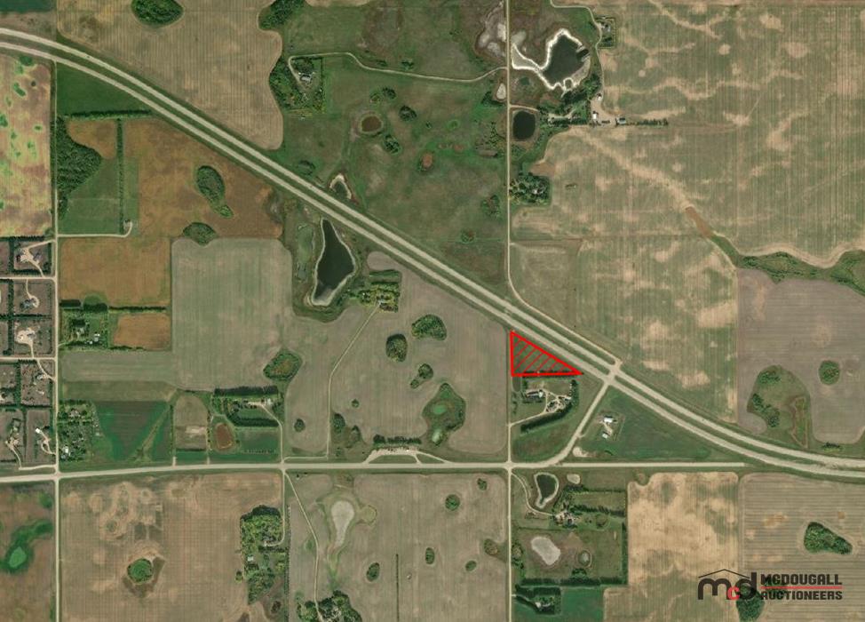
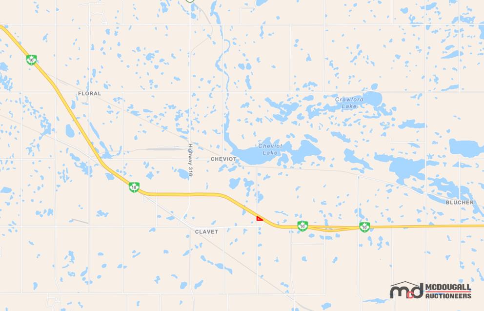
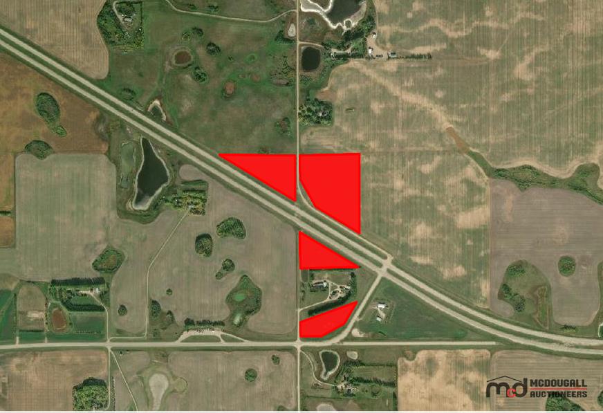
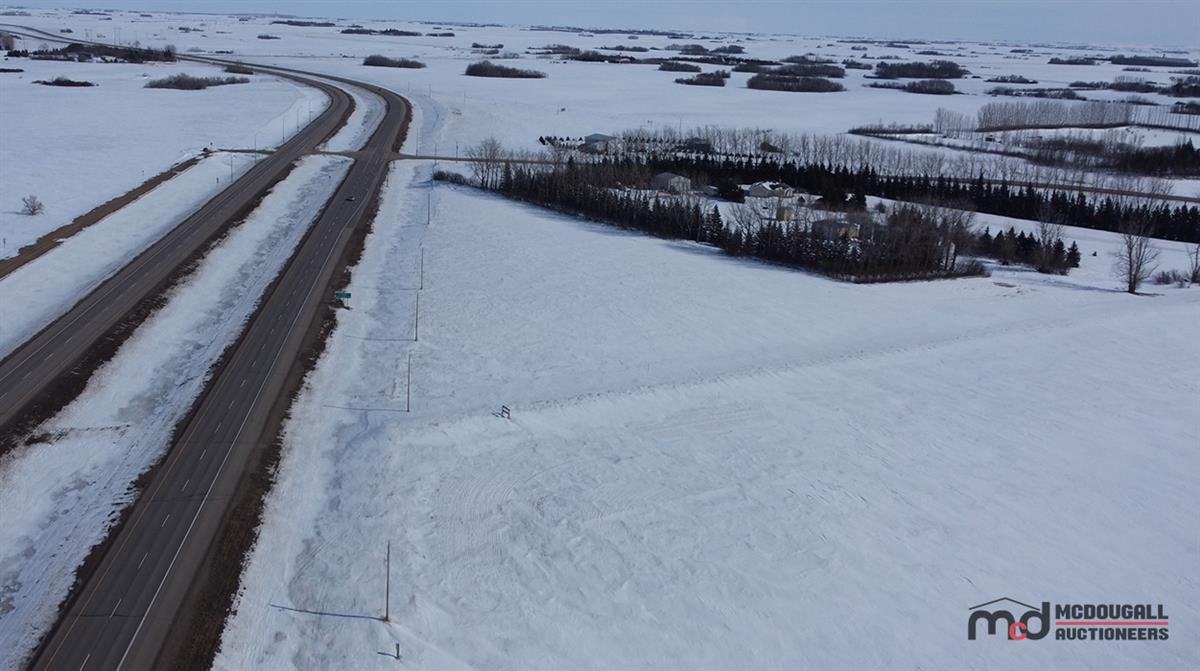
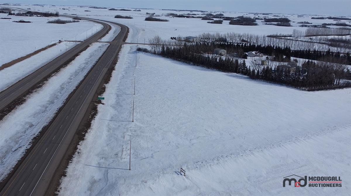
Parcel U - RM of Blucher No. 343 - (4.6 Acres)
Pick up location: Highway #16, Clavet, SK
Lot: 1529
Listing Details
Features and Specifications
| Other Description: |
| Welcome to the RM of Blucher No. 343, Saskatchewan. |
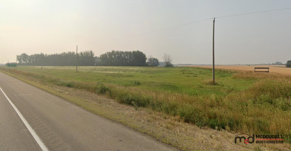
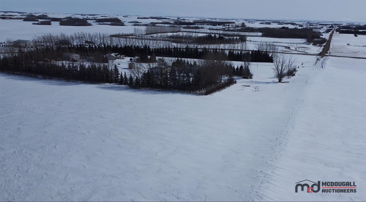
| The RM of Blucher is located to the immediate east of the City of Saskatoon, SK. The Northern RM boundary is Highway 5, and it is divided roughly equally north and south by Highway 16. Occupying a total land area of 789 square kilometers, it has a population count of 1984 as of the 2021 census. This property is located adjacent to Highway 16, on the south side of the highway roughly one mile east of Clavet, SK |
| -------------------- |
| Property Information: |
| Legal Land Description: Parcel U Plan 102191093 |
| Source Quarter: SW 14-35-03 W3 |
| GPS Coordinates: 52.001628, -106.336626 |
| ± 4.6 Titled Acres |
| ± 4 Estimated Cultivated Acres |
| Ag Usage: Cultivation |
| Access to the property: Trail |
| Crop History: Not Available |
| SAMA Assessment: Not Available |
| Estimated Yearly Property Taxes: Not Currently Assessed, Taxes cannot be estimated until assessment is completed |
| -------------------- |
| Additional Information: |
| Purchase is subject to the completion of the Sale Agreement, Please see copy below for full details. |
Lot Overview
| Scheduled Viewing Dates & Details:
Vacant Land, please go direct. Do not drive onto the property, Walk in only, Please respect adjacent property owners. Terms and Conditions: Auction will close on Tuesday, May 13, 2025. 1. Upon close of auction the highest bidder will be required to pay a non-refundable deposit with certified funds to McDougall Auctioneers of 10% plus the Buyer's Fee and applicable taxes within 24 hours. If you are the highest bidder, your refundable deposit will automatically be applied to and become part of your non-refundable deposit. 2. Remainder of funds to be paid into trust with your lawyer within 21 business days of acceptance of sale. 3. The Purchaser shall be responsible for the costs of its solicitor and for the costs of registration of the appropriate transfer document(s), and any mortgage costs it might incur. 4. Possession to occur upon Title Transfer. 5. All auction items are sold buyer beware and as is where is. 6. Subject to a $2000 Buyers Fee. 7. Sold free and clear of all liens and encumbrances. Please note specific easements as detailed on each parcel. 8. Offers may be subject to the approval of appropriate parties. 9. This Auction is Reserved. THIS AUCTION SALE REQUIRES PRE-REGISTRATION!! A refundable deposit of $5,000 is required to participate in this sale. Please allow a minimum of 24 hours to be registered. NO FINAL DAY REGISTRATIONS WILL BE PERMITTED. Please contact our Real Estate office to start the registration process. Prior to contacting our office, please ensure you have your bidding account for mcdougallauction.com completed and set up. For More Information Regarding This Sale, Please Contact: Cory Hall at 306-541-4409 or 306-271-1505. |
Documents
Pick Up & Conditions
Terms
TERMS & CONDITIONS - Cash, Debit, Certified Cheque, Corporate Creditor Or Online Payments. (2.4% Convenience Fee On Credit Card Transactions) - Buyer's Fee of $2,000 per Lot. - Subject To Additions & Deletions.