- Home
- About
- Team
- Contact
-
Categories
- Aggregate
- Agriculture
- Aircraft
- Attachments
- Construction Equipment
- Articulated Dump Trucks
- Asphalt Pavers
- Asphalt Plant & Components
- Backhoe Loaders
- Boom Lifts
- Boring Equipment
- Compact Track Loaders
- Compactors
- Concrete Mixing
- Concrete Paving
- Concrete Plant & Components
- Concrete Pump
- Crawler Dozer
- Directional Drill
- Excavators
- Forklifts
- Front Shovels
- Generators
- Light Towers
- Mechanical Frame Trucks
- Motor Graders
- Scissor Lifts
- Scrapers
- Skid Steers
- Soil Stabilizers
- Telehandlers
- Water Wagons
- Wheel Loaders
- Wheeled Dozers
- Consumer Items
- Cleaning Machines
- Clothing
- Construction Materials
- Consumer Electronics
- Generators
- Heating & Cooling Equipment
- Household Goods
- Industrial & Construction Supplies
- Luxury Goods
- Medical Equipment
- Office Equipment
- Parts
- Portable Structures
- Product & Fuel Tanks
- Scrap Metal
- Sheds
- Shipping Containers
- Shop Equipment
- Shop Tools
- Sporting Goods
- Storage Wars
- Survey Equipment
- Traffic Control Equipment
- Warehouse Equipment
- Waste & Recycling Equipment
- Water Equipment
- Welding Equipment
- Yard & Garden
- Cranes
- Forestry Equipment
- Marine Support & Infrastructure
- Military
- Oil & Gas
- Rail
- Real Estate
- Restaurant Equipment
- Trailers
- Boosters
- Container Chassis
- Curtain Side Trailers
- Deck Over Trailers
- Dollies
- Dual Lane Trailers
- Dump Trailers
- Equipment Trailers
- Food & Concession Trailers
- Fuel & Lube Trailers
- Gooseneck Trailers
- Highboy Trailers
- Jeeps
- Lavatory & Shower Trailers
- Live Bottom Trailers
- Livestock Trailers
- Logging Trailers
- Lowboy Trailers
- Office Trailers
- Oilfield Float Trailers
- Pneumatic Bulk Trailer
- Pole Trailers
- Pressure Washer Trailers
- Reefer Trailers
- Reel Trailers
- Refuse Trailers
- Roll Off Trailers
- Sand Blasting Trailers
- Scissorneck Trailer
- SPMT's
- Spray Foam Trailer
- Steam Trailers
- Step Deck Trailers
- Tank Trailers
- Trailer Components
- Trombone Trailers
- Utility Trailers
- Vacuum Trailers
- Van Trailers
- Water Craft Trailers
- Vehicles
- Vocational Trucks
- Asphalt Trucks
- Bed Trucks
- Beverage Trucks
- Bridge Inspection Trucks
- Bucket Trucks
- Cab & Chassis
- Car Carrier Trucks
- Chip Trucks
- Concrete Mixer Truck
- Concrete Pump Trucks
- Curtain-Side Truck
- Digger Derrick
- Dump Trucks
- Emergency Vehicles
- Feed Trucks
- Flatbed Trucks
- Food & Concession Trucks
- Fuel & Lube Trucks
- Grain Trucks
- Grapple Trucks
- Hook Lift Trucks
- Hot Oil Trucks
- Hydro-Vac Trucks
- Logging Trucks
- Lugger Trucks
- Reefer Trucks
- Reel Trucks
- Refuse Trucks
- Roll-Off Trucks
- Semi Trucks
- Service Trucks
- Sewer & Cleaning Trucks
- Shunt Trucks
- Silage Trucks
- Slinger Trucks
- Snow Plow Trucks
- Steam & Wash Trucks
- Sweeper Trucks
- Tank Trucks
- Tow Trucks
- Traffic Control Trucks
- Vacuum Trucks
- Van Trucks
- Water Trucks
- Welding Trucks
- Winch Trucks
- Auctions
- Real Estate
- Locations
- FAQ
- Services
- How to Pay
- Careers
- Français

Issues with our payment partner have been resolved. We apologize for the inconvenience.
Time Left:
Bidding History
- Loading . . .
Time Left:
Location:
RM's #001 - 622, SK
by placing a bid you agree to all
terms and conditions of mcdougallauction.com
Time Left:
Location:
RM's #001 - 622, SK
by placing a bid you agree to all
terms and conditions of mcdougallauction.com
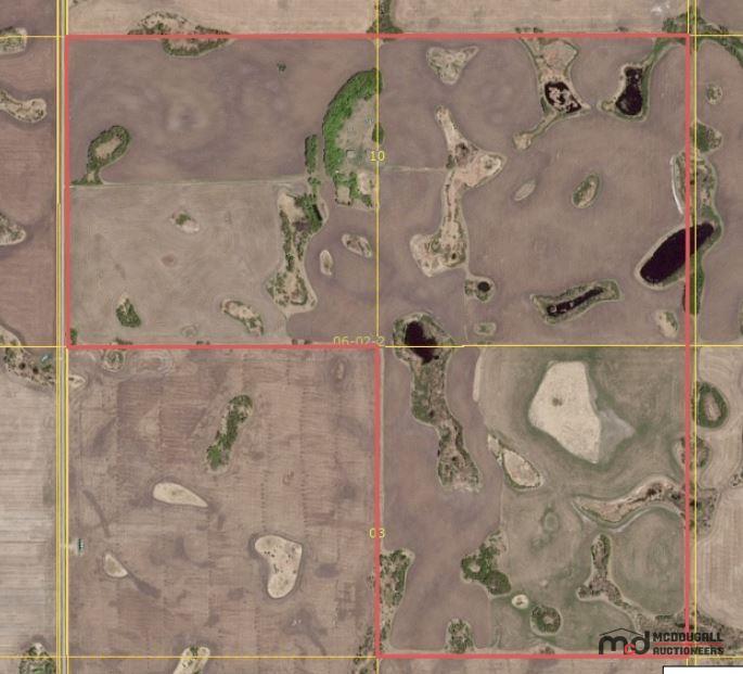
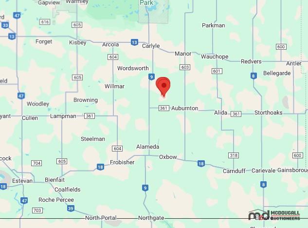
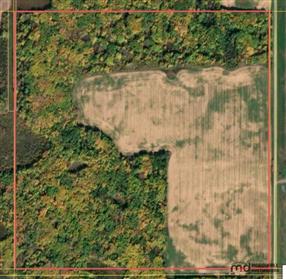
RM of Moose Creek # 033 - NE-03, SE & SW 10-06-02 W2 (480 Acres) - Crown Land Sale
Pick up location: RM's #001 - 622, SK
Lot: 1552
Listing Details
Features and Specifications
| Other Description: |
| Property Information: |
| Legal Land Description: NE 03-06-02 W2, SE 10-06-02 W2, SW 10-06-02 W2 |
| GPS Coordinates: 49.453722, -102.197148 |
| ± 480 Titled Acres |
| ± 415 Estimated Cultivated Acres |
| Crown Conservation Easement: NO |
| Integrated Land Use - Crown Conservation Easement: NO |
| Ag Usage: Cultivation |
| Livestock Water Source: No |
| Access to the property: All Weather via SW-10 |
| Crop History: Not Available |
| Improvements: Water Well on SW-10 |
| SAMA Assessment: $774,300 - Please see SAMA Assessments below for additional information |
| Estimated Yearly Property Taxes: $2015 |
| -------------------- |
| Additional Information: |
| Parcel includes various buildings and bins that are damaged and in various states of disrepair. The buyer is responsible for any associated clean-up or removal of structures from the land. For further information, please reach out to the district Land Management Specialist, Laine Radwell, at 306-787-5601. |
| The Ministry makes no representations, assurances or guarantees as to the amount, quality, potability, or fitness for purpose of any surface water, ground water, or water in any dugout, reservoir, channel or well situated on or under the premises. |
Lot Overview
| VIEWING:
Please go Direct, please use the Coordinates provided below for Google Map Directions to each property. For More Information, Please Contact the Real Estate Team at 1-306-271-1505 or by email at realestate@mcdauction.com Additional Information is available on each property, please check the bottom of this page for more information. |
Detailed Description
| Notice: At the request of the Ministry of Agriculture, the Crown Land Sale Auction is temporarily paused. Further information will be provided as soon as possible. |
Documents
Pick Up & Conditions
Terms
TERMS & CONDITIONS - Cash, Debit, Certified Cheque, Corporate Creditor Or Online Payments. (2.4% Convenience Fee On Credit Card Transactions) - Buyer's Fee of $1,500 per Lot. - Subject To Additions & Deletions.